Did you know that Google Maps allows you to know not only the location of a place, but also the weather conditions that surround it? This information is important to plan your day. But how do you know the weather and air quality of a place on Google Maps?
If you are organizing an outdoor excursion, a city visit or simply want to know if you need to bring an umbrella, this article is for you.
Google Maps , the most used mapping tool in the world, offers integration with various weather forecasting and air quality monitoring services , which are very useful for keeping you informed about the environmental conditions of any place.
Therefore, today you will not only learn how to know what the weather will be like on a trip , but also how to know the air quality of a place we are going to on Google Maps. Everything in one place, do you dare? Let’s get started!
How to know what the weather will be like on a trip on Google Maps
If you like to go out and organize camping and adventure days, it is possible that one of your main concerns is how to know what the weather will be like on a trip on Google Maps , especially if you want everything to go perfect.
Fortunately, Google’s service provides a detailed view of the weather along your planned route , along with crucial air quality index (AQI) information. To view the details, follow these steps:
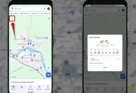
- Enter Google Maps from your Android or iOS mobile device.
- In the top left corner of the screen, just below the search bar and place filters, you’ll see a small rectangular box . This box will display the current temperature, weather icon, and Air Quality Index (AQI).
- Tap the box to get more details about the weather along your route.
- You can then view a card with additional weather information , such as wind chill, high and low temperatures, as well as a 12-hour forecast. You can also explore the air quality by tapping the AQI section.
If you don’t see this feature on your device, make sure you have the latest version of Google Maps . You can update the application from the official store, both for Android and iOS .
How to know the air quality of a place we are going to on Google Maps
Air pollution is a problem that affects everyone, especially those who suffer from respiratory diseases. If you are one of them, you are most likely wondering: how to know the air quality of a place we are going to on Google Maps .
The steps described above provided an idea of air quality through the (AQI) section. However, with these steps you will have more information.
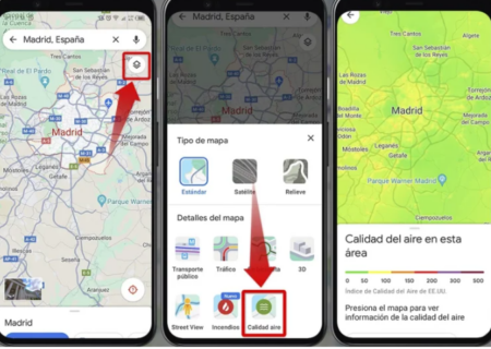
- Launch the Google Maps app on your Android or iOS mobile device.
- In the search bar, locate the place you will visit soon.
- Once you’ve selected your location, look at the map and look for a small rectangular box in the upper left corner of the screen.
- A window will open with 2 sections. In “Map details” click on the “Air quality” box to see the air quality in that area.
- Next, you’ll see information about air quality, along with other weather data.
- If you want to check the air quality in different areas and places, simply repeat these steps to find and select other locations on Google Maps.
As you will see, the steps to know the weather and air quality of a place on Google Maps are not complicated at all and are very useful for planning your daily activities.
And if you like everything related to Google Maps, don’t forget to take a look at how to see the streets in Google Maps from your mobile and how to make a route in Google Maps and save it .